
contained_parcel · glossary · deed-checked (test)
Owner of 013030 0300 is outside Owner of 013030 0010 Ridge by record; cut Owner of 013030 0300 from Owner of 013030 0010
Proposed · test result · high · status: proposed (not applied, not a finding) · overlap 21798.54 sq ft
larger parcel's legal excepts a deed of the smaller parcel
Parcels & ORB references
| parcel | owner (PA) | ORB book-page |
|---|---|---|
| 013030 0010 | Owner A | 20536-00187, 20427-02030, 19128-02196, 18341-00341, 12782-00217, 12782-00215 |
| 013030 0300 | Owner B | 13639-00288, 10793-00035, 06873-01960, 06434-00478 |
Deed traverse · ORB 13639-288
—
Green = deed calls drawn segment by segment (best-fit placement, no monument tie); orange/red = GIS outlines.
Deed evidence
{"owner_0130300300": "ORB 13639-288 (WD 2006, metes & bounds w/ lake meander)", "owner_0130300010": "ORB 20536-187 (WD 2022, plat ref Tracts 12-13 Blk 1 PB 5-93)"}
acres record cogo chorded: 0.339 · acres gis owner 0130300300: 0.5 · acres gis owner 0130300010: 7.382
- Owner of 013030 0010 deed ORB 20536-187 (plat reference, no bearings) expressly excepts 'Official Records Book 13639, Page 288' = the Owner of 013030 0300 deed
- Owner of 013030 0300 COGO matches GIS on bearing sides (IoU 0.667, chorded lake side 220.8 ft vs 344 ft meander explains 0.34 vs 0.50 ac)
- GIS Owner of 013030 0300 100% inside GIS Owner of 013030 0010
Overlay figure
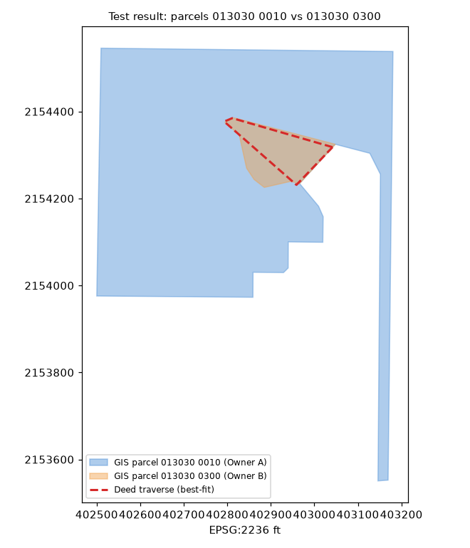
Figure generated from county GIS outlines and the best-fit deed traverse (no aerial basemap; parcel IDs only). Data quality test result, not authoritative.